Starting from the centre of Cap d’Ail you head east along the main street until you come to a small side road called Chemin des Mimosas, turn up it and after a few steps follow it round to the right. This hike starts with a fair bit of asphalt, but the scenery is nice and although you’re going uphill the gradient is not too taxing. You also get to have a nose at fancy villas on the way past. This little pedestrian road will take you behind the houses and up a number of staircases until you come out on the main road RD6007 (Moyenne Corniche). Here you need to cross at the traffic lights and follow Chemin des Cyclamens opposite until you come to your first signpost for the Tete de Chien on the left.
The route is not always obvious as the first part alternates between residential backstreets and small footpaths for a little while but it is well marked, you just need to keep your eyes open for the yellow paint that leads the way. Once you’ve crossed the final road (Grande Corniche) you’re on the trail proper and in a wilderness of limestone, cacti, wild herbs and tangled flowers.
The higher you get, the more stunning the scenery becomes and you see further and further along the coast. The high cliffs above you keep giving way to more beautiful views each time you turn a corner, because the path zig-zags up the rocks you constantly see the landscape from different perspectives. Someone obviously likes to contemplate the view up here, as about halfway up there is a makeshift bench made out of slabs of rock.
It’s not just hikers that you’ll meet on the path, the area is a popular trail running route and a number of the cliffs are bolted up for rock climbing. Rather them than me in this heat…
The trail is rough underfoot and rather overgrown in places, but this all just adds to the charm. Although it can be steep in places, the gradient is generally pleasant and you’ll find that you stop so often anyway to look at the view that you shouldn’t find it too hard. Decent shoes are recommended due to the hard stony path and hiking poles come in useful for the occasional steep section.
The path twists and turns until it comes out onto an open plateau at 556m, strewn with boulders and long grass. Atop the plateau is a large stone building that looks a bit like a military installation but is in fact a telecommunications research centre with a large white ball perched on top that peers out of the long grass, like in The Prisoner…
From here you pick up signs for Tete de Chien (tour) in order to circle round the summit, partly on asphalt, and rejoin the path on the other side of the big building. There are picnic tables up here and although the area itself isn’t pretty the views are impressive. You can see right along the coastline in both directions and way out over the mountains as you look inland towards the medieval fortress town of La Turbie.
The name of the hike comes from the fact that when it is plotted on a map it looks like the head of a dog (kind of, if you squint and use a lot of imagination). Apparently old documents describe it as being a mastiff squatting over Monaco - presumably by someone who wasn’t a big fan of Monaco.
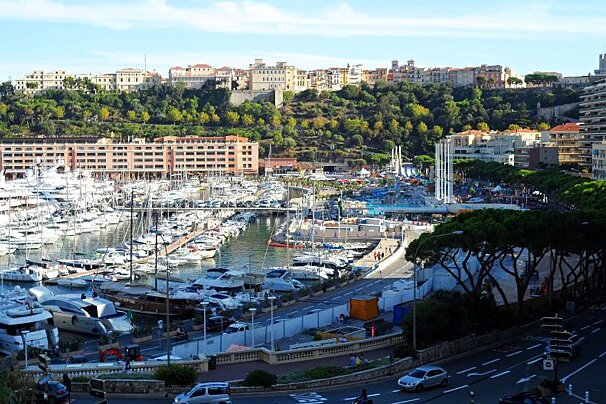
From up here though you get fantastic views of that legendary port and as you descend you feel as though you are leaning right out over it. The path back down is a bit steeper than the one up, so if you brought hiking poles this would be a good time to use them. It’s perfectly doable without though, you just have to mind your step on some sections.
The path loops around, so that you get a whole new perspective on the scenery and as you get closer to Cap d’Ail the pale sand and bright blue bay of Plage Marquet comes tantalisingly into view. This hike is very exposed and on a hot day you will be in full sunshine - the sea looks very tempting from here.
Towards the end of the hike someone has inconveniently built a couple of swish villas with terraced gardens and outdoor pools that you have to pick your way around, it’s all signposted though and there is the option to branch off and head to Monaco if that takes your fancy.
Otherwise, keep following signs to Cap d’Ail and you’ll soon find yourself back in a residential area from where it is an easy walk back down to the town.